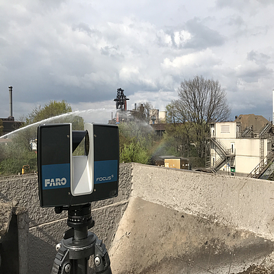
The sigma3D team offers you customized measurement solutions that provide greater planning reliability and lower costs. We capture your buildings, warehouses, and facilities quickly, flexibly, and reliably as complete 3D data sets.
Whether it’s a machining cell or an entire factory complex: With terrestrial laser scanning (TLS), we can capture all structures visible from the ground. You’ll benefit from the high measurement resolution (point density) and impressive accuracy of just 1.5 mm. The entire scanning process takes only a few minutes. For larger measurement areas, our experts seamlessly merge multiple point clouds to guarantee you a complete and detailed result.
Your benefits at a glance


During the scanning process, our high-precision laser scanner uses a rotating mirror to capture up to 1 million measurement points per second in a 360-degree rotation. The result: a highly detailed 1:1 representation of reality, presented as a three-dimensional point cloud containing millions of points. Depending on the object’s characteristics and distance, the accuracy of the measurement data ranges from 1 to 3 millimeters.
Optionally, we use an integrated camera during the scanning process to capture 360-degree images. This allows the 3D point cloud to be automatically colored and then rendered in a photorealistic manner.
This informative visualization provides you with an optimal representation. You can also explore your 3D models virtually—using VR headsets or directly in your browser. This improves planning and facilitates decision-making.
Terrestrial laser scanning (TLS) is used in many fields where precise surveying is required.
These include sectors such as:
Our laser scanning replaces traditional methods such as manual measurement with a tape measure and plumb line. We can capture indoor and outdoor objects for you 100% digitally with impressive precision.
Unlike kinematic laser scanning, which delivers data very quickly but is severely limited in accuracy, the use of stationary scans allows us to generate a point cloud with very high accuracy.
The result: a meaningful 3D model that can be accessed at any time, offering significant time and cost savings—primarily by eliminating the need for repeated on-site measurements. The wide range of applications extends from strategic planning and practical simulation to comprehensive construction monitoring and legally admissible evidence preservation.


